Some Lindsay's Found in Early Westmoreland County, Pennsylvania Land Records

The Lindsay's discussed here arrived early in the area.  They were likely to have come from eastern counties while on military duty, and they claimed land at an early date.  Three of the men, Arthur, James, and William Lindsay Jr., had claims prior to 1769.  They received certificates for 300 acres each in the 1769 Pennsylvania land lottery, which was established to settle disputes over prior land claims.  Because the land the Lindsay's claimed was clustered very close to each other in South Huntingdon Township, it seems they may have been related to each other.  It is not known if they actually lived on the land, or claimed it for speculative purposes and lived elsewhere.  Below are the records I've collected concerning these Lindsay's and their lands.

 
vvvv
This tract was owned by William Lindsay Jr.  It was on the north side of Sewickley Creek.  Lindsay had sold it to Robert Miller by 1773.      
vvvv
Casper Markle (Merklin) owned this tract, directly south across the river from the land William Lindsay claimed.  Markle later purchased the land Lindsay had formerly owned.
vvvv
James Lindsey owned this tract. He may have had a family in the area, including a son, John Lindsey, who married Eleanor Carnahan.
vvvv
Arthur Lindsay received a warrant for this tract, which he had surveyed in 1770. 
vvvv
Clements Finley owned this tract, which was on the opposite side of Sewickley Creek from William Lindsey's claim. Finley was married to Elizabeth Carnahan.  When Finley died in 1775, Alexander Lindsay witnessed his will.

              
This image is a portion of a warrant map of South Hungtingdon Township.  Source: Early Landowners of Pennsylvania: Westmoreland Co. Patent Maps,  CD by Ancestor Tracks.


The map above is from the David Rumsey Collection: Reading Howell's 1792 Map of Pennsylvania

Timeline:

1769: New Purchase Lottery certificate #738 issued to William Lindsay Jr. for 300 acres on the "east side of Seweekly about five miles above the mouth including the creek above Finley's Run".  This is the yellow area on the maps, above.  The land was surveyed in 1787 by Isaac Miller "in right of William Lindsey".

New Purchase Register: http://www.phmc.state.pa.us/bah/dam/rg/di/r17-43NewPurchaseRegister/r017-43NewPurchReg%2076.pdf

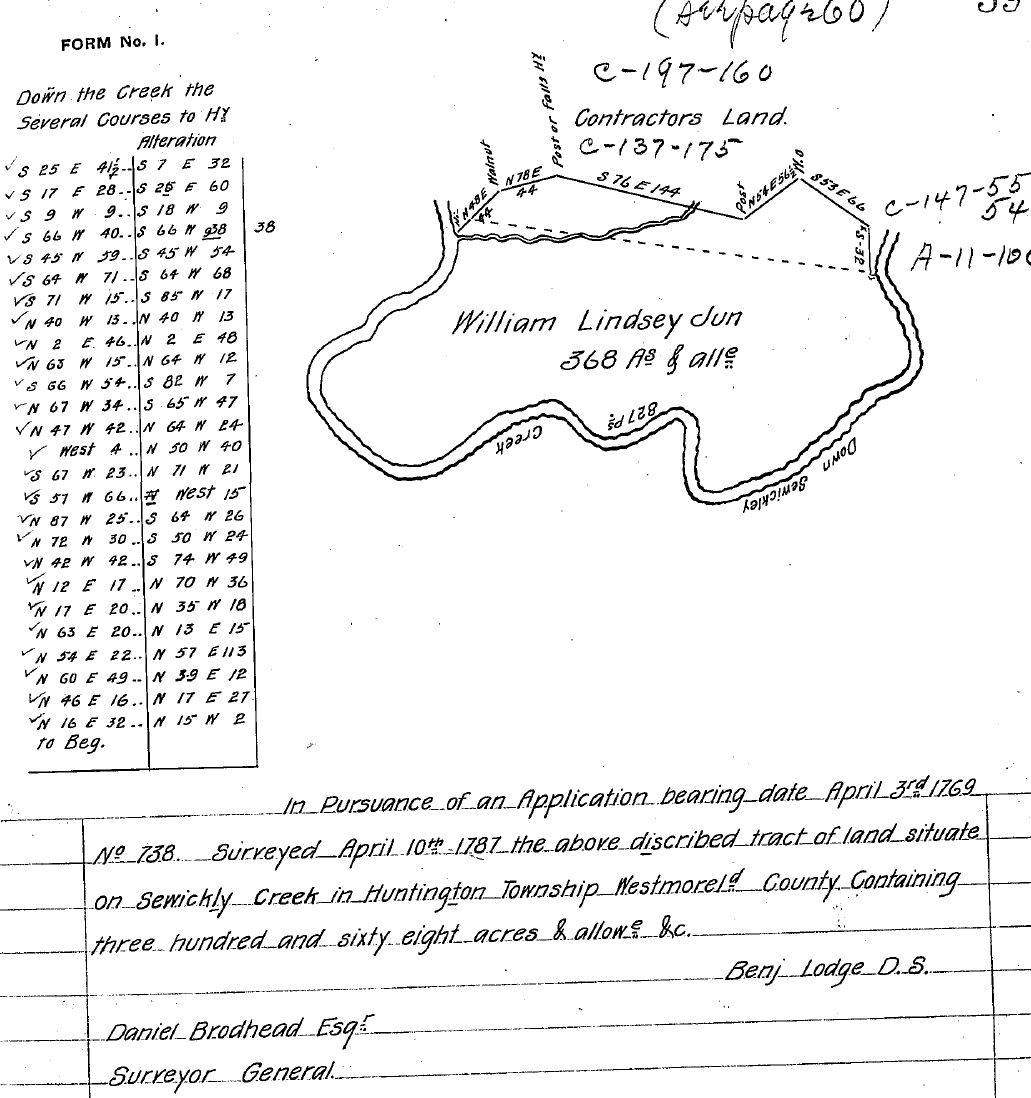
1769: New Purchase Lottery certificate #1850 issued to James Lindsay for 300 acres on the "East branch of Sewickley about 5 or 6 miles above ye mouth of sd. Creek including the  Run is called Turlow about 1 mile or more from the mouth of sd. Run."  This is the aqua area on the maps, above. John Carnahan had the tract resurveyed in 1785. A return was issued to Benjamin Miller in Trust in 1827.  John Carnahan's 1824 will mentioned his daughter, Eleanor "Nelly" Lindsay.  Eleanor Carnahan's husband, John Lindsay (b. by 1765), may have been the son of James Lindsay, the original owner of this tract.  John and Nelly Lindsay later lived in Venango Co., PA where John had died by 1820.

New Purchase Register: http://www.phmc.state.pa.us/bah/dam/rg/di/r17-43NewPurchaseRegister/r017-43NewPurchReg%20185.pdf

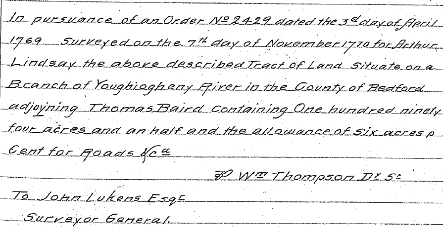
1769: New Purchase Lottery certificate #2429 issued to Arthur Lindsay for 300 acres on  "one of the branches of the Yough (Youghiogheny River) on the north side about 5 miles above the mouth of Sewickly adjoining Thomas Baird East." This is the green area on the maps, above.  

New Purchase Register: http://www.phmc.state.pa.us/bah/dam/rg/di/r17-43NewPurchaseRegister/r017-43NewPurchReg%20244.pdf
 

1770: The above mentioned tract was surveyed for Arthur Lindsay.  A note on the back of the survey says that Jacob Smith was issued a warrant to accept in 1787.  It is not known if Arthur Lindsay ever lived on the land.  He did not appear in any tax records for the area.  This researcher has found no other records for Arthur Lindsay in the area.

http://www.phmc.state.pa.us/bah/dam/rg/di/r17-114CopiedSurveyBooks/Books%20C1-C234/Book%20C193/Book%20C-193%20pg%20575.pdf


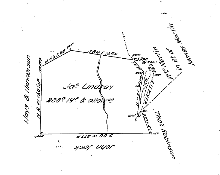
1773: William Lindsay witnessed the will of Thomas Sumrall/Simeral (Westmoreland Co., PA Will Book 1, Page 1). The map of Westmoreland Co., above, shows the name Sumeral just above the yellow dot which represents the location of William Lindsay's land.  The Simeral family operated a ferry on the Youghiogheny River in this area.  Thomas was the son of Alexander and Jean Lindsey Simeral (m. ca. 1737) who had moved to Westmoreland Co. from Chester Co. ca. 1773.  Jean was the daughter of Samuel Lindsey of Chester Co. (Source: The Abridged Compendium of American Genealogy, edited by Frederick A. Virkus.  Baltimore, Genealogical Publishing Co., 1968: Volume VII, Lineage Records, Pages 134 and 400).

1773:  Gedison Miller sold 400 acres of land on Sewickley Creek to Casper Miracle.

Source: FHL film # 0929165
Westmoreland County Deed Book Vol. A, Pg. 271: Gedison Miller to Casper Miracle 27 Sep. 1773
Huntingdon Township, on waters of Big Sewickley, 400 acres
Adj.: Robert Miller, Clement Finley, Thomas White, Thomas Smallman
Witnesses: Henry Smith, James Kinkead

 
This was Markle's land on the south side of Sewickley Creek (colored orange, above) in South Huntingdon Twp.  William Lindsay's claim was directly opposite on the north side of the creek in present day Sewickley Twp.  Since William Lindsay was not named as an adjacent owner, but Robert Miller was, I'm assuming that Lindsay had already sold his interest to Robert Miller before 1773.  See 1774 for more on the location of Markle's land.
 
1773: Survey Book C-197, Page 160: William Sherer had his land surveyed near Sewickley Creek.  Robert Miller's land was shown as being south of and adjacent to Sherer's. Lindsay must have sold his interest to Miller by this date.

Survey Image: http://www.phmc.state.pa.us/bah/dam/rg/di/r17-114CopiedSurveyBooks/Books%20C1-C234/Book%20C197/Book%20C-197%20pg%20319.pdf
 

1774: Warrants (#'s 79 and 80) issued to Peter and Casper Merckelin for 191 and 200 acres in Huntingdon Township.

Warrant Register: http://www.phmc.state.pa.us/bah/dam/rg/di/r17-88WarrantRegisters/WestmorelandPages/Westmoreland86.pdf

Survey Image: http://www.phmc.state.pa.us/bah/dam/rg/di/r17-114CopiedSurveyBooks/Books%20C1-C234/Book%20C142/Book%20C-142%20pg%20303.pdf

The image below is from Survey Book C-142, page 152. The survey took place in 1785.  Land north of Markle's was shown as being owned by the heirs of Robert Miller, who had died in 1775.  Land just east of Markle's was shown as being owned by the heirs of Clemens Finley, who had also died in 1775.


 1775: Clement Finley died in South Huntingdon Twp.  Alexander Lindsay witnessed his will (Westmoreland Co., PA Will Book 1, Pg. 5).  Lindsay may have been a neighbor.  Clement Finley had married Elizabeth Carnahan.  Finley's tract (colored purple, above) was adjacent to Gaspar Miracle's land on the south side of Sewickley Creek.  See the image, above, for Casper Markle's survey.

1775:  Robert Miller was killed by Indians.  Isaac Miller was named in his probate as his oldest son (Westmoreland Co., PA Will Book 1, Page 6).  In 1787, Isaac Miller had the land surveyed that had been formerly owned by William Lindsay Jr. on Sewickley Creek.
http://freepages.genealogy.rootsweb.com/~treasures/pa/westmoreland/lettersofadmin/letterslovez.htm
 
1776: Sgt. William Lindsay of Capt. James Carnahan's company of the 13th PA regiment of Westmoreland  Co. died after being taken captive at the Battle of Long Island.  I'm not sure if this is the same William Lindsay who had the land on Sewickley.  It appears he may have lived on Beaver Run in present day Salem Twp., but it was in Hempfield Twp. then.
 

FHL Film #0929165
Westmoreland Co. Deed Book Vol. A

Pg. 84
William Masson to William Lindsay, both of Hempfield
For 30 pounds, 300 acres on waters of Beaver Run
Adj: William and Mathew Jack, John Christie, and others. Consentable lines between Alexander Thompson's land.
Signed William Mason, 5 Jun 1775.


Pg. 432
William Lindsay to Samuel Whitsett, both of Hempfield Township
For 50 pounds, 300 acres on the waters of Beaver Run, being the same land
conveyed by Mr. Mason to John Mason, unto William Lindsay. Bounded by lands
of: John Christy, William Jack, William Graham, and others.
Signed William Lindsay, 26 March 1776
Witnessed by James Kinkead.


More on the soldier William Lindsey who died in 1776: http://mimpickles.com/lindsey/william_of_fort_pitt/1776/william_died_1776.html


1783: PA Archives Series 3, Vol. 2, Pages 314-315 - Two Isaac Miller's were taxed in Huntingdon Twp.  One for 300 acres and one for 60 acres.  Gasper Mercial was taxed for 400 acres.  Hezekiah Lindsey was taxed for 150 acres, while John Lindsey was taxed as single.
 
1785: Survey Book C-144 page 201: John Carnahan had 288 acres resurveyed on an order to survey dated 1769 for James Lindsay.

Survey Image: http://www.phmc.state.pa.us/bah/dam/rg/di/r17-114CopiedSurveyBooks/Books%20C1-C234/Book%20C144/Book%20C-144%20pg%20401.pdf


1787:  Survey Book C-142 page 59.  386 acres on Sewickley Creek surveyed for William Lindsey.  Page 60: Isaac Miller had the same land surveyed "in right of William Lindsay".   Both surveys took place on April 10th. 


Survey Image: http://www.phmc.state.pa.us/bah/dam/rg/di/r17-114CopiedSurveyBooks/Books%20C1-C234/Book%20C142/Book%20C-142%20pg%20117.pdf
 
Survey Image: http://www.phmc.state.pa.us/bah/dam/rg/di/r17-114CopiedSurveyBooks/Books%20C1-C234/Book%20C142/Book%20C-142%20pg%20119.pdf
 

1795: James Lindsay to Jno. Carnahan.  Westmoreland Co., PA. Deed Book Vol. 2, Pg. 139, 10 Feb 1795. (Source: Grantor Index Surnames H-L, FHL film #929098)

1800: John Lindsey to Silas Clark, land in South Huntingdon Twp.  Westmoreland Co., PA. Deed Book Vol. 5, Pg. 208, 29 Mar 1800. (Source: Grantor Index Surnames H-L, FHL film #929098)

1802: John and Eleanor Lindsay to Joseph McCracken, land in South Huntingdon Twp.  Westmoreland Co., PA Deed Book Vol. 6, Pg. 201, 15 Mar 1802. (Source: Grantor Index Surnames H-L, FHL film #929098)

1805: John Lindsay to Jno. Rob, land in South Huntingdon Twp. Westmoreland Co. Deed Book Vol. 7, Pg. 395, 17 Jun 1805. (Source: Grantor Index Surnames H-L, FHL film #929098)
 

1817: Survey Book C-137, page 175 - Susannah Miller had 49 acres surveyed, in trust, for the heirs of Isaac Miller, deceased.  This land appeared to be just north of the 386 acre parcel.

Survey Image: http://www.phmc.state.pa.us/bah/dam/rg/di/r17-114CopiedSurveyBooks/Books%20C1-C234/Book%20C137/Book%20C-137%20pg%20349.pdf
 
1824:  John Carnahan, formerly of South Huntingdon Twp. Westmoreland Co. but then of Venango Co., wrote his will.  His daughter Eleanor had married John Lindsey.  The will named Nelly Lindsay's children: Jane, Rebecka, Mary, Robert, James, and Findley. (The 1810 census for French Creek, Venango Co. lists John Linsey, age 45+, and his family.  The 1820 census for French Creek lists Eleanor Lindsay as head of household. It appears John had died sometime before 1820.)
 
Source: J. V. Thompson Journals, Vol 1., Page 3.  Thompson cited Westmoreland Co., PA Will Book 2, Page 152:

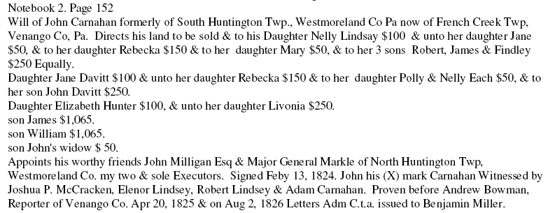
1826: Benjamin Miller received letters of administration for the estate of John Carnahan of Venango Co.  Source: J. V. Thompson Journals, Vol 1., Page 3.  Thompson cited Westmoreland Co., PA Will Book 2, Page 152.


 Susan Grabek